New Houseboat
on Lake Mead
|
|


|
Call now to
see this boat:
480-444-9377
|
|

|
LAKE PLEASANT
REGIONAL PARK
About the Lake
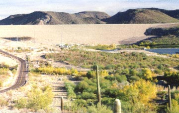
The "Carl" Pleasant Dam, later renamed Waddell Dam, was constructed between 1926 and 1928, creating the upper portion of the Lake. At this time it was the largest agricultural Dam in the world. The Dam stood 76 feet in height and 2,160 feet in length. At 126 feet above streambed, its elevation was 1,601 feet. It created a Lake with 3,706 surface acres of water having a shoreline of 50 plus miles. The objective was to impound runoff waters, from the Agua Fria River and the Bradshaw Mountains, for irrigation purposes. The dam was built by the predecessor to the Maricopa County Municipal Water Conservation District #1. The Maricopa County Municipal Water District, based in Beardsley, Arizona, continues to manage the irrigation system for the benefit of west valley farmers. In 1959, Maricopa County leased State Trust land and Federal land to form a park surrounding the lake. Since 1969, Maricopa County Municipal Water Conservation District and the County have maintained a cooperative relationship whereby farmers and the recreating public have realized the maximum utilization of this water resource.
New Waddell Dam
 In 1968, Congress authorized the Bureau of Reclamation (BOR) to construct the Central Arizona Project with the goal of transporting Colorado River water to central and southern Arizona for municipal, industrial, and agricultural use. To implement this plan, a regulatory storage reservoir was needed to store water near its users.
Since the existing lake was not large enough for this purpose, the Federal government proposed construction of a New Waddell Dam. The new dam was completed in March 1993. It raised the water level by 100 vertical feet and increased the overall lake volume from 157,000-acre feet to 860,000-acre feet. The resultant water surface area increased from 3,528 acres to 9,966 acres.
The new high water mark was reached for the first time in April 1994. Seasonal water demands could still result in as much as a 100 vertical drawdown with restoration during the winter months. The Central Arizona Water Conservation District determines the water level of the Lake. The Lake receives water from the Agua Fria River and canal water from the Central Arizona Project (CAP) reaching elevation at high water mark 1,702 feet above see level, normally in Mid-Spring. In June, the drawdown cycle begins with water released from the Lake through the CAP canal for irrigation of the West Valley Agricultural Areas during the summer months. The Bureau of Reclamation is now the landowner of all the property under and around Lake Pleasant, with the exception of 225 acres deeded to the Maricopa Water District, located near the southeast corner of the lake. In 1990, Maricopa County entered into a long-term (50-year) management agreement with the Bureau of Reclamation.
That agreement stipulated that Maricopa County manage recreation and public safety, both on and off the water, of the remaining 24,000-acre regional park. That agreement empowered the County to enter into third-party concession agreements, with the approval of the Bureau of Reclamation.
In 1968, Congress authorized the Bureau of Reclamation (BOR) to construct the Central Arizona Project with the goal of transporting Colorado River water to central and southern Arizona for municipal, industrial, and agricultural use. To implement this plan, a regulatory storage reservoir was needed to store water near its users.
Since the existing lake was not large enough for this purpose, the Federal government proposed construction of a New Waddell Dam. The new dam was completed in March 1993. It raised the water level by 100 vertical feet and increased the overall lake volume from 157,000-acre feet to 860,000-acre feet. The resultant water surface area increased from 3,528 acres to 9,966 acres.
The new high water mark was reached for the first time in April 1994. Seasonal water demands could still result in as much as a 100 vertical drawdown with restoration during the winter months. The Central Arizona Water Conservation District determines the water level of the Lake. The Lake receives water from the Agua Fria River and canal water from the Central Arizona Project (CAP) reaching elevation at high water mark 1,702 feet above see level, normally in Mid-Spring. In June, the drawdown cycle begins with water released from the Lake through the CAP canal for irrigation of the West Valley Agricultural Areas during the summer months. The Bureau of Reclamation is now the landowner of all the property under and around Lake Pleasant, with the exception of 225 acres deeded to the Maricopa Water District, located near the southeast corner of the lake. In 1990, Maricopa County entered into a long-term (50-year) management agreement with the Bureau of Reclamation.
That agreement stipulated that Maricopa County manage recreation and public safety, both on and off the water, of the remaining 24,000-acre regional park. That agreement empowered the County to enter into third-party concession agreements, with the approval of the Bureau of Reclamation.
[ Lake Pleasant Home ] [ About the Lake ] [ Camping ]
[ Boating ] [ Events ] [ Fishing ]
[ History ] [ How To Get There ] [ Map of the Park ]
[ Picnicking ] [ Lake Pleasant Amenities ]
|
|
 |
 |
|
|